
|
|---|
The Science Data Modeling and Computing Group's Current Projects
|
CMDA: Climate Model Diagnostic AnalyzerSeungwon Lee, Benyang Tang, Lei Pan, and Chengxing ZhaiThe objective of this project is to build a collaborative research platform that integrates relevant datasets and analysis tools and supports the full life cycle of data analysis, from data discovery, to data customization, to analysis, to reanalysis, to publication, and to reproduction. CMDA was initially developed to demonstrate the methodology to evaluate and diagnose climate models through the comprehensive use of multiple observational data, reanalysis data, and model outputs. It has evolved to support collaborative scientific activities and the full life cycle of data analysis. |
|---|---|
|
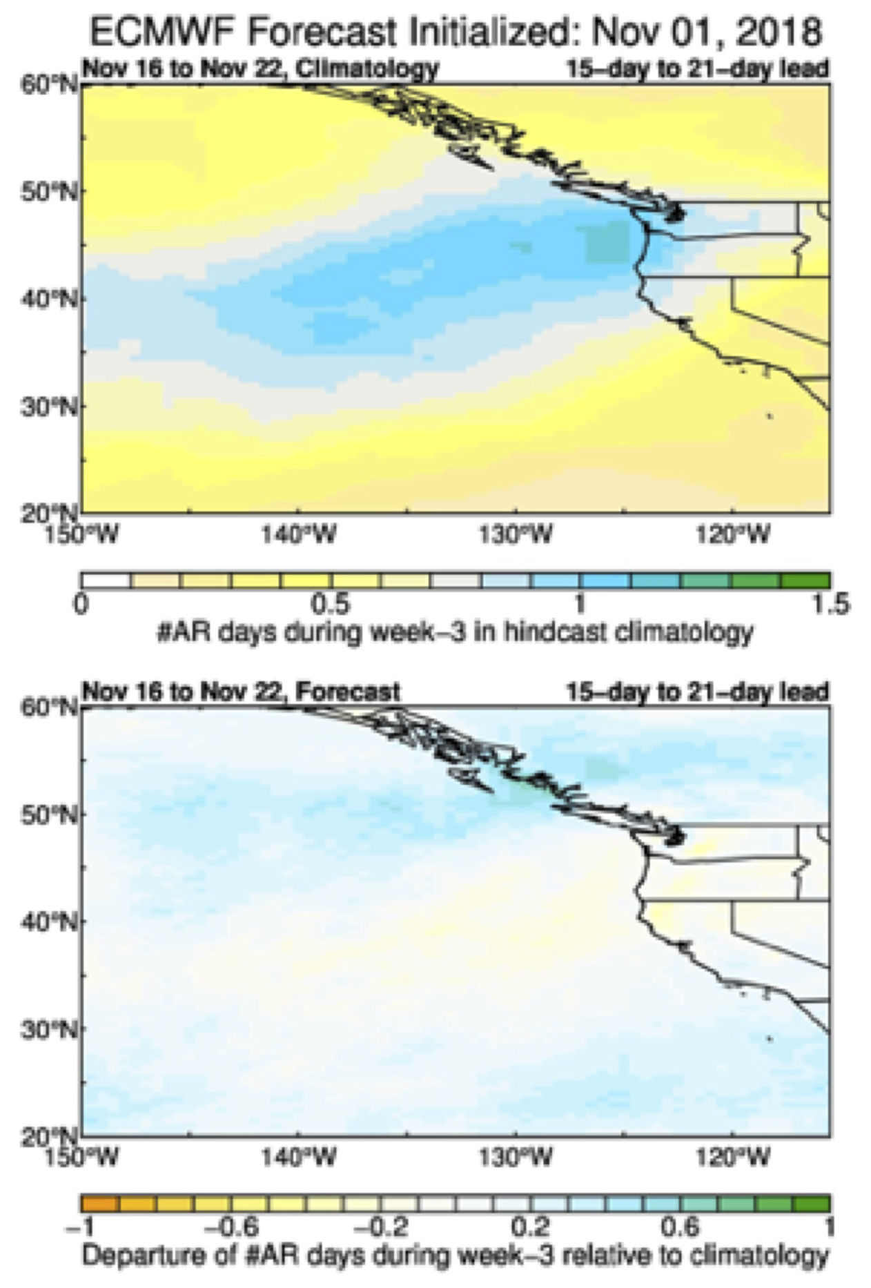
Realtime Forecasting of Atmospheric Rivers for CaliforniaAlexander GoodmanWith concerns about the increasing threat of droughts in California with future climate change, properly managing water resources is key. Our team at JPL is collaborating with California’s department of water resources to provide realtime forecasting capabilities of atmospheric rivers. These large scale flows of water vapor in the upper atmosphere account for a significant percentage of all rainfall events on the west coast. |
|
Extreme Weather InitiativeLongtao WuThe project objective is to strengthen JPL’s capabilities to develop and conduct breakthrough scientific advances in extreme weather, focusing on Observing System Simulation Experiments (OSSEs) for improved mission formulation capabilities. One identified key weather focus area of this project is 3D winds. Dr. Longtao Wu provides high-resolution regional and global model simulations, applies wind tracking algorithm to track winds from the simulated moisture, and evaluates instrument-based AMV uncertainties and their impacts on weather forecast. |

|
Ecological ForecastingPeter KalmusThe goal of the project is to better translate Earth System Model projections into forecasts for specific ecosystems, starting with coral reefs. This 3-year project will identify potential coral reef refuges using observationally weighted climate model ensembles, downscaling, and statistical ecological modeling. Two goals are to disseminate our results to the world’s reef managers, who can prioritize conservation of identified refugia; and creating a general framework for ecological forecasting. This work is funded by NASA ROSES A.8: Sustaining Living Systems. |
|
Tornadogenesis from SpacePeter KalmusThe objective of this project is to determine, from remote sensing, environmental factors distinguish tornadic supercells from non-tornadic supercells; to improve forecasting lead times for tornadoes; and eventually to shed light on how tornadoes might change as the planet warms. I am a Co-I and the primary data analyst, designing and implementing the analyses. This work is funded by NASA and NOAA. |
|
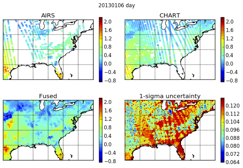
Data FusionPeter KalmusThe objective of this project is to develop methods for fusing measurements of a single process (e.g. near-surface temperature, relative humidity, or vapor pressure deficit, a measure of plant stress) made by multiple satellites into a single, better product. In addition to the fundamental goal of improving how we extract information from satellite remote sensing, we are also producing improved data records for applications such as drought, fire, and agricultural forecasting. I am leading the analysis. This work is funded by NASA's AIRS project. |
|
Marine Boundary Layer Stratocumulus-to-Cumulus TransitionPeter KalmusThe objective of this project is to better understand the physics of stratocumulus clouds, especially factors controlling the transition of stratocumulus to lower-albedo cumulus clouds in western subtropical ocean basins. My role is to design and implement data analysis and provide scientific insight. This work is funded by NASA. |
|
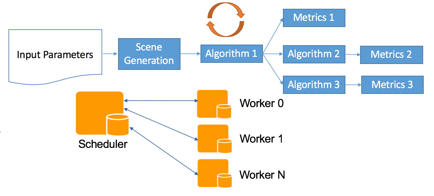
Mission Performance Prediction Models and AnalysisWilliam Lincoln and Emily DunkelBuild models to predict performance across key parameters, evaluate algorithm performance, execute algorithm trade studies, and tune algorithms to optimize performance metrics. Develop a data pipeline architecture that supports big data analytics, is deployable in multiple environments, and is distributed and scalable. Bills' contributions are to develop performance predition models with image processing and machine learning algorithms and define the expected performance metrics. Emily’s contributions are to develop machine learning-based computer vision algorithms, and improve data analysis pipelines. |
|
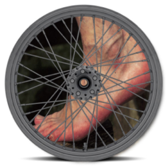
Barefoot RoverPaul SpringerWe select a few sample machine learning kernels, implement them in C on a Mac laptop initially, then port them to the RAD-750 computing platform, and finally parallelize and port to the HPSC and Emu platforms. The goal is to compare performance on the HPSC and Emu computers and compare with RAD-750 performance. |
|
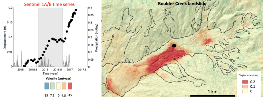
Multi-Temporal Anomaly Detection for SAR Earth ObservationsGiangi SaccoThe project which is funded by ACCESS aims to use a cloud-based Machine Learning Framework to enable large-scale event detection such as landslides, volcano activities and flooding. The goal is achieved by analyzing SAR time series that allow change detection at the millimeter level and by training a Machine Learning Model that is able to detect anomalies in the expected behavior over time. |
|
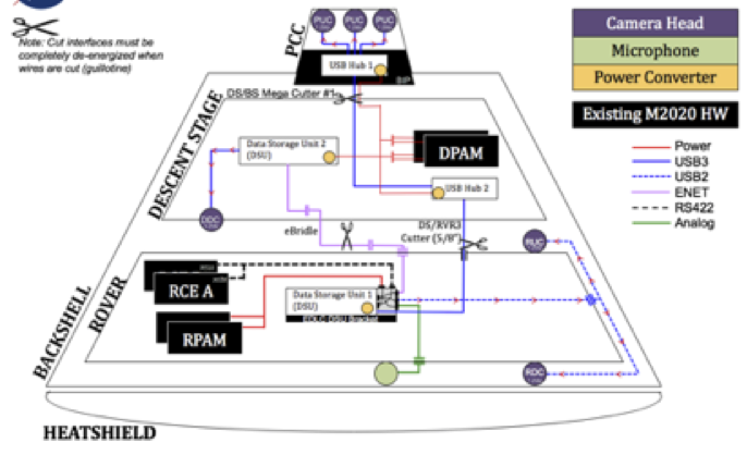
Mars 2020 EDL CameraGary BlockThe Mars 2020 EDL Camera will record the lowering of the Rover onto the surface of Mars. There are 6 cameras. Three high speed cameras will record the parachute deployment form inside the parachute deployment mortar. Another camera will record the lowering of the Rover onto Mars. There are two cameras on the Rover. One looking down at the surface of Mars. The other will look up at the sky crane as it lowers the Rover. The cameras on the Rovers will remain in service during surface operations. |
|
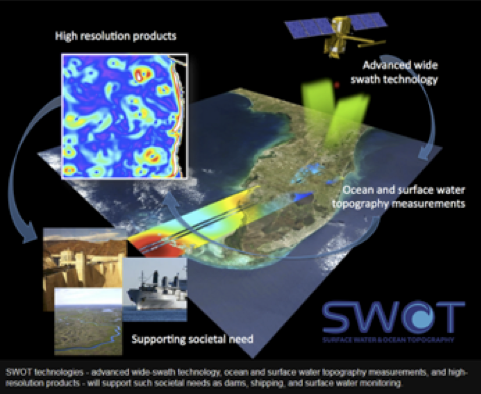
Surface Water and Ocean Topography (SWOT)Kacie Shelton and Trinh VoSWOT measures water height around the globe via radar interferometry, providing high-detail maps of water topography and measure how water bodies change over time, bringing together oceanographers and hydrologists from around the world. We work in various parts of the SWOT science data system (SDS). Everything from defining requirements for the SDS, detailing interfaces between the SDS, MOS, GDE, and ADT, to working on the algorithms to translate the raw data stream into science data ready for science processing. |
|
Modeling-Driven MSL Surface Operations OptimizationGreg MooreGoal: Maximizing science return envelopes while minimizing energy usage through full MSL thermal systems modeling and simulation. Approach: Thermal analyses are facilitated by Cielo, a highly-parallelized, extensible, finite element-based code for integrated thermomechanical analysis, coupled with an automation layer to drive seasonal and diurnal controlled preheat scenarios and data collection. Role: Chief Software Architect and Developer |
|
Juno: Microwave RadiometerFabiano Oyafuso and Virgil AdumitroaieThe Juno Microwave Radiometer (MWR) measures microwave radiation stemming from up to several hundred kilometers deep into Jupiter’s atmosphere. Its principal objective is a determination of Jupiter’s total water abundance. Fabiano’s role is to develop algorithms that map measured microwave intensities into global maps of thermal emission and ultimately to ammonia and water distribution. Virgil's role is to develop synchrotron radiation modeling and estimate the contribution of the synchrotron radiation to the brightness temperature measured by the MWR antenna back lobes. |
|
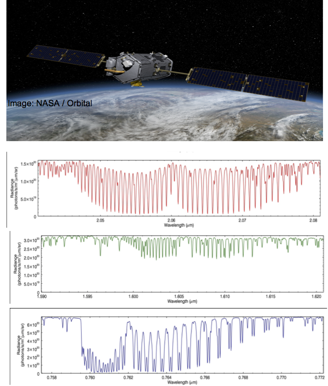
OCO-2: SpectroscopyFabiano Oyafuso and Alex GuillaumeThe primary objective of OCO-2 is to determine global column CO2 abundances to within ~1ppm. An essential component to meeting this objective is an accurate description of the spectroscopy of the absorbers present within the spectral ranges the instrument measures. Fabiano’s principal contribution is to validate recent advances (both experimental and theoretical) in the description of absorption by H2O, CO2 and O2 with ground-based measurements and to incorporate them into products used by OCO-2 retrieval of CO2 dry air mole fractions. |
|
Observational System for Contraining Clouds and Precipitation in Atmospheric ModelsKay SuseljDesign of a modeling study to help plan mission priorities and measurement requirements for future atmospheric observations. We will answer the following five questions: Which observations would be most useful to constrain physical processes that are responsible for cloud, convection and precipitation formation in atmospheric models? Which observations would be most useful for future atmospheric model development? What is the minimum requirement to make a significant impact with respect to the horizontal, vertical and temporal resolution of such observations? What biases, errors and uncertainties are acceptable? |
|
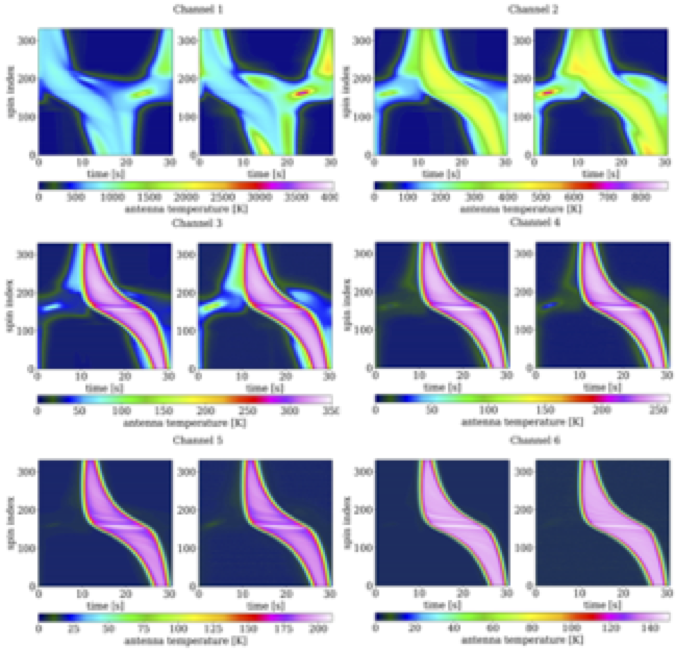
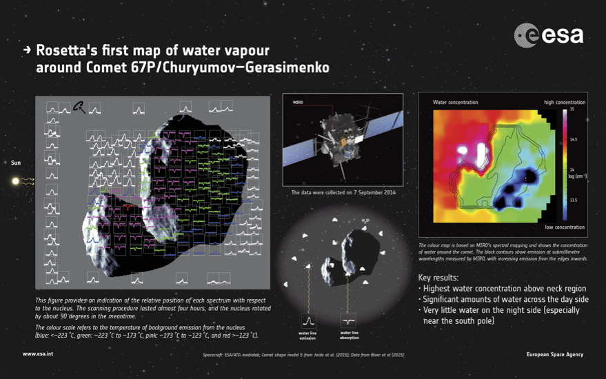
Rosetta MIRO Data Processing and ArchivingSeungwon Lee and Lei PanMIRO is a JPL's microwave instrument onboard the ESA's comet chasing Rosetta spacecraft. MIRO's primary objectives are to understand the nature of the cometary nucleus, outgassing from the nucleus, and formation of the cometary coma through the broadband measurements of near-surface thermal emissions near 190 GHz and 562 GHz and the spectral measurements of four volatile species - CO, CH3OH, NH3, and H2O near 562 GHz. Seungwon has been a Co-investigator of the MIRO science team and has developed the calibration and retrieval methods for MIRO spectral measurements. Lei has been the system architect and developer of the MIRO data processing software pipeline and the corresponding web services. Lei has generated MIRO calibrated and higher-level data products and delivered them to PDS for archival. |
|
|
Near-Earth-Object Orbit Determination using High Precision Astrometry and ParallaxChengxing Zhai and Navtej SainiNear-Earth-Object (NEO) orbit determination is crucial for cataloging newly detected NEOs. Using simulation and observational data, this project studies how accurate astrometry and parallax can improve the efficiency of determining orbits of NEAs, i.e. using the least amount of measurements/integration time to determine orbits of NEAs accurate enough for predicting their next close apparition without ambiguity. |
|
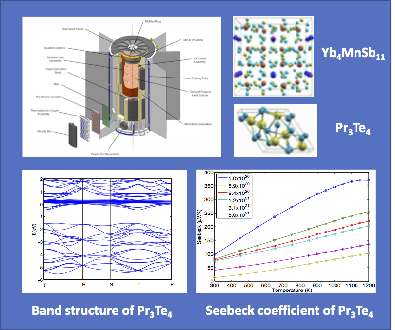
Fundamental Research of Thermoelectric MaterialsTrinh VoRadioisotope Thermoelectric Generators (RTGs) can provide electricity and heat for a variety of space missions, using plutonium dioxide (primarily Pu-238) as fuel. The current generation of RTGs convert only 6.5% of this heat to electricity. The challenge is to improve the heat-to-electricity conversion (g), and one of the ways to do so is to find thermoelectric materials that can yield an optimal value of the figure of merit. The objective of this project is to use first principles computation to study the relation between electronic structures and thermoelectric properties of complex materials in support of experimental efforts at JPL. The calculations should allow for a rapid exploration of the compositional and structural parameter space in search of materials with higher figures of merit. This will reduce the number of new materials that need to be synthesized and tested in the laboratory. |
|
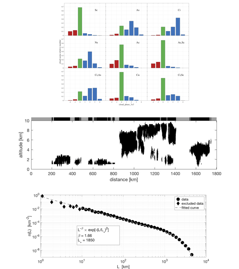
Multidecadal Water Vapor, Temperature, and CloudsAlexandre GuillaumeThe goal of this project is to create a record of all satellite sounder temperature and water vapor observations, matched to simultaneous, collocated imager cloud observations, on platforms launched by NOAA, NASA and EUMETSAT since 1998. Searching for a relationship between cloud states and water vapor, Dr. Guillaume has been studying cloud properties from the Atmospheric Infrared Sounder (AIRS) as a function of CloudSat cloud types. Mixtures of cloud top types, termed cloud scenes, were used to assess the characteristics of spatially collocated AIRS thermodynamic phase and ice cloud property retrievals within scenes of varying cloud type complexity. CloudSat cloud size distributions were derived to better characterize cloud scenes. |
|
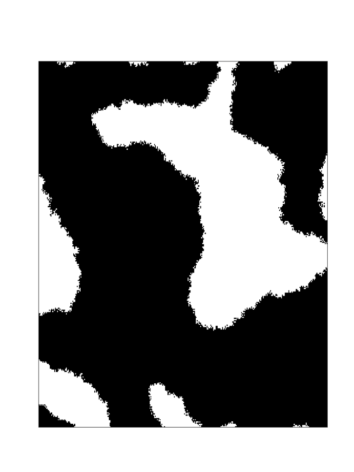
Evaluating 3D radiative transfer effects on Earth's albedo with cloud distributions observed from spaceAlexandre GuillaumeThe objective of this project is to evaluate quantitatively to what degree the plane-parallel approximation in climate models leads to errors and biases in radiative transfer (RT) calculations. The main goal is to provide the first global assessment of the 3D radiative effects of clouds, with a focus on the shortwave band relevant for Earth’s albedo. Dr. Guillaume has been designing a stochastic cloud model that can generate three-dimensional (3D) cloud fields partially based on CloudSat observations. |
|
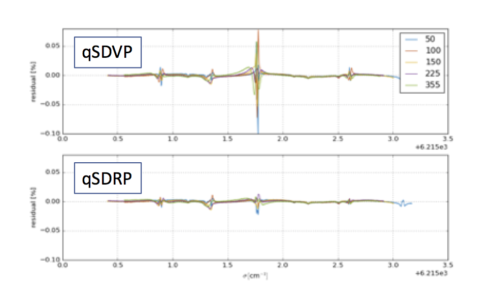
Advances in Spectroscopic Line Shapes and Application to Remote SensingAlexandre Guillaume and Fabiano OyafusoAccurate spectroscopic input is a key component of accurate radiative transfer calculations. Our ability to accurately model of molecular absorption in the atmosphere is limited by uncertainties in our knowledge of spectroscopic line parameters and line shape. The spectroscopy community, recognized that the Voigt line shape parameterization was not sufficiently accurate and decided to adopt a more advanced “standard” line shape parameterization, known as the Hartmann-Tran Profile (HTP). Dr Guillaume implemented this HTP lineshape in a multi-spectrum fitting framework and tested the applicability of this lineshape formulation with laboratory measurements. He is working with the OCO-2 science team to update the multi-spectrum program with the necessary physics to describe the spectroscopy as better laboratory spectra become available. |
|
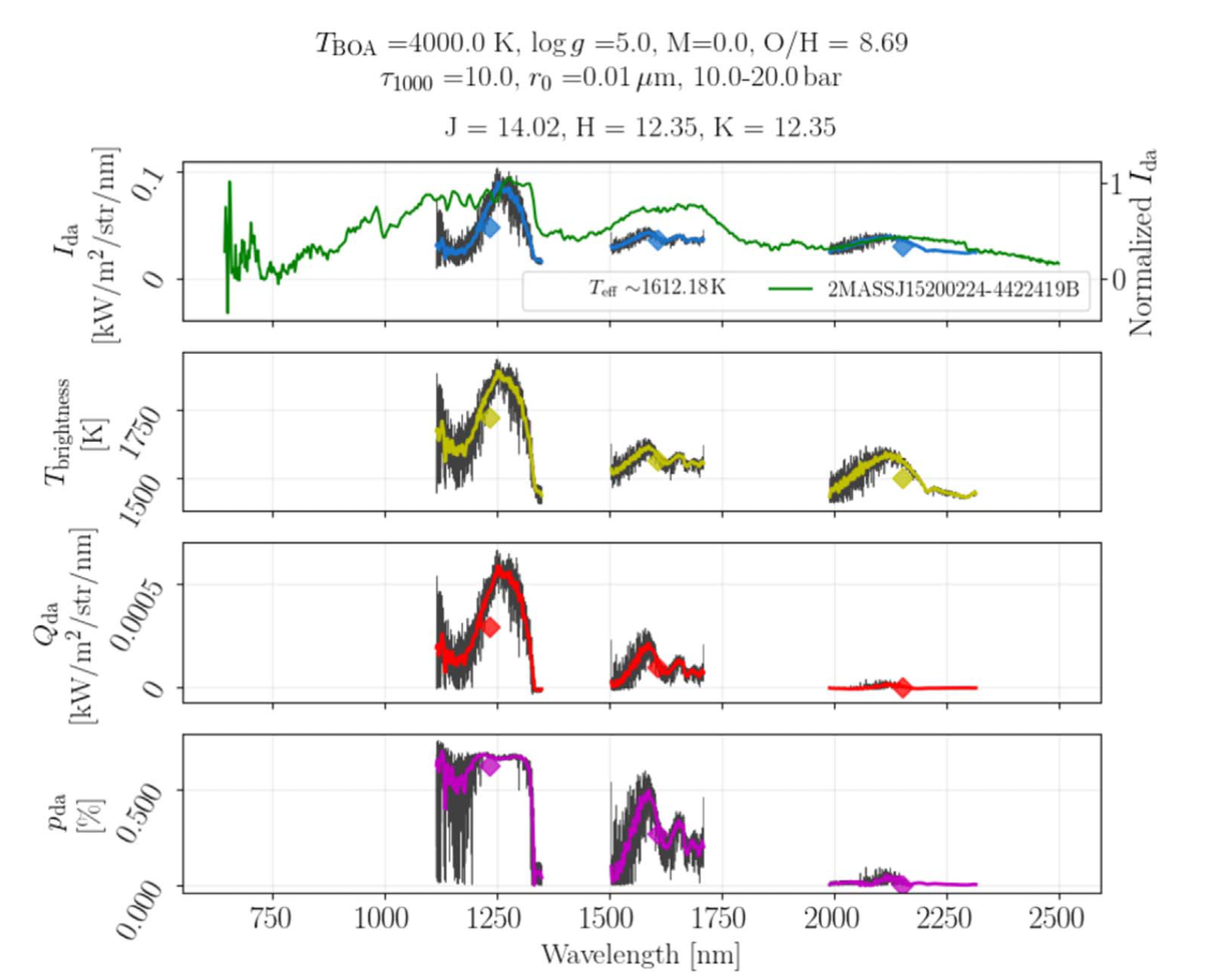
Spectropolarimetric Simulations of Brown DwarfsSuniti SanghaviScattering processes in the atmosphere of a fast-rotating brown dwarf produce distinct spectrometric and polarimetric signatures. An ability to unambiguously interpret these signals would improve our understanding of their atmospheric evolution, structure, and dynamics. Using our recently developed semi-analytic conics-based radiative transfer framework we have generated realistic spectro-polarimetric simulations and have examined the simulated effects of the internal energy and surface gravity of BDs and of the grain size and atmospheric depth of clouds on polarized spectra in the J, H, and K near infrared bands. |
|
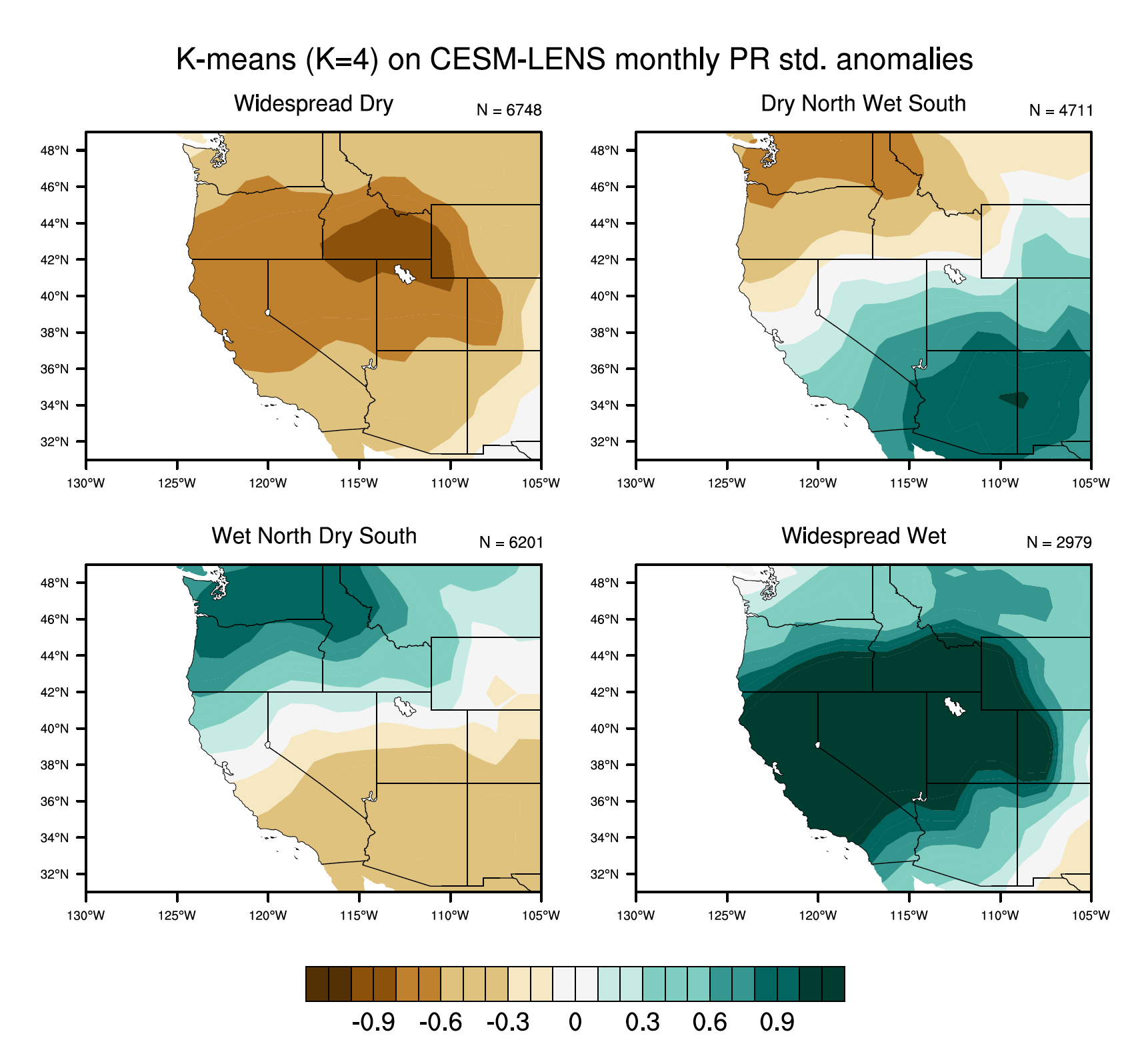
Next Generation Earth System PredictionAlphan AltinokMillions of people turn to their weather stations to get the latest weather forecast. Knowledge of what the weather will be in the next several days has tremendous impact on vast industries and on the society as a whole. What if there were similar forecasts for 1, 3, or even 6 months from now? The objective of this work is to identify subseasonal to seasonal (S2S) forecasts that can be predicted 1-12 months in advance. The benefits of S2S forecasts will increase if their operational scope is extended beyond the traditional weather variables to include more Earth system variables and events: for example, better prediction of the ocean state, sea ice fields, air quality, and water management. Dr. Altinok applies machine learning methods to improve the current state of the S2S forecasting focusing on the western U.S. |
|
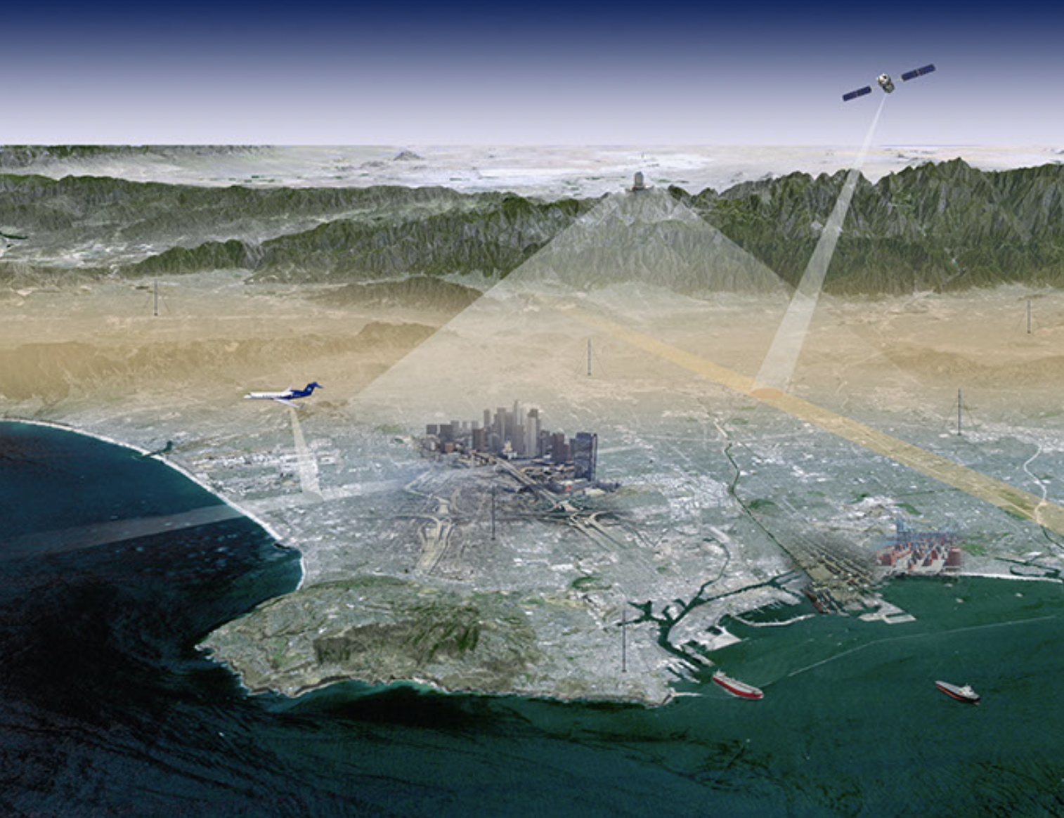
Multi-tiered Carbon Observing SystemsDaniel CusworthThis project brings together any and all observations of carbon greenhouse gases (e.g., methane and CO2) into a data assimilation framework to improve our understanding of the carbon budget on regional scales. Observation systems include satellite, airborne, mountaintop, and surface monitors. We assimilate these observations together with an atmospheric transport model to infer emission fluxes at kilometer scales. This multi-tiered system was prototyped in Los Angeles, where multiple observations systems exist, but we are now expanding to other key regions globally. |
|
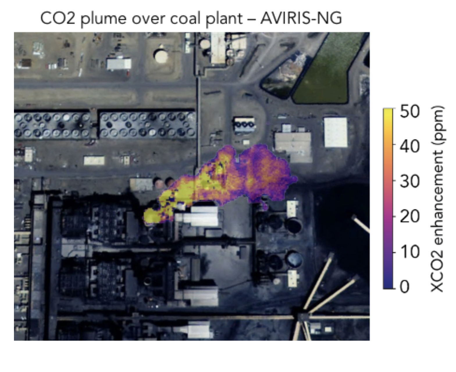
Remote sensing of CH4/CO2 plumes from imaging spectrometersDaniel CusworthRecent or soon to launch satellite imaging spectrometer missions (PRISMA, EnMAP, EMIT, SBG, CHIME) have the capacity to retrieve atmospheric trace gases (CH4/CO2) around very large emission sources, i.e., “super-emitters.” The benefit of these instruments compared to other atmospheric sounders is the very fine scale spatial resolution (30-60m), which allows for unambiguous source attribution. This project prototypes retrievals for these spectrometers, based on similar work from the AVIRIS-NG airborne instrument. In the case of launched instruments (i.e., PRISMA), we are actively surveying the globe’s largest CO2/CH4 emitters to test its capability to constrain emissions. |
|
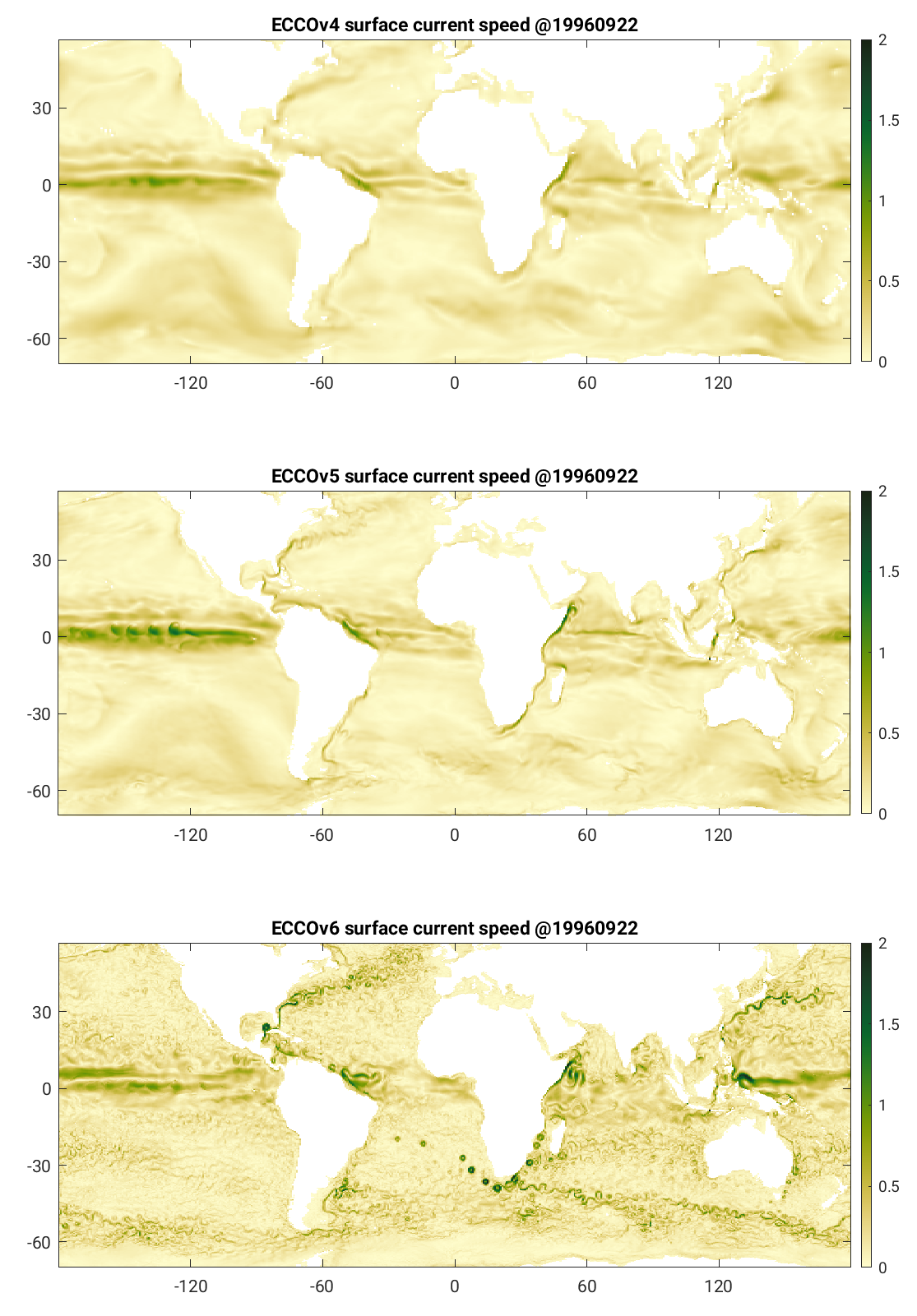
Estimating the Circulation and Climate of the Ocean (ECCO): Towards Eddying RegimeHong ZhangECCO consortium makes the best possible estimates of ocean circulation and its role in climate by combining state-of-the-art ocean circulation and sea-ice model with global ocean observations. Similar to conventional ocean "reanalyses", ECCO reconstructs the ocean and sea-ice state by fitting the model to agree with observations in a statistical sense. However, only ECCO can fully explain the underlying physical causes and mechanisms behind ocean and sea-ice state and varialibity because ECCO reproduces observations in a physically and statistically consistent manner. Eddy, the ocean "storm", is ubiquitous in the global ocean. It plays an important role in ocean circulation, air-sea interaction, transport, and mixing. The current ECCO products (ECCOv4 and v5) only estimate eddies by parametrization because of lower resolution model (35–100km horizontal spacing). Next generation ECCO (v6 and on) aims to solve meso-scale and even sub-meso-scale eddies by working to develop and improve higher-resolution (18 km and finer) model. |
|
Exoplanet WatchKyle PearsonExoplanet Watch is a citizen science project to observe transiting exoplanets — planets outside our solar system — with small telescopes. A transiting exoplanet is one that periodically passes in front of its host star, causing the star to appear dimmer (by about 1%). Observing exoplanet transits is important, as they allow us to directly measure a planet's radius and atmospheric composition. Ground based follow up from a network of observers will allows us to better constrain the planet’s orbital solution (e.g. period, time of mid-transit and semi-major axis). These constraints will help increase the efficiency of exoplanet studies on large telescopes by reducing uncertainty about the predicted timing of transit events. |
|
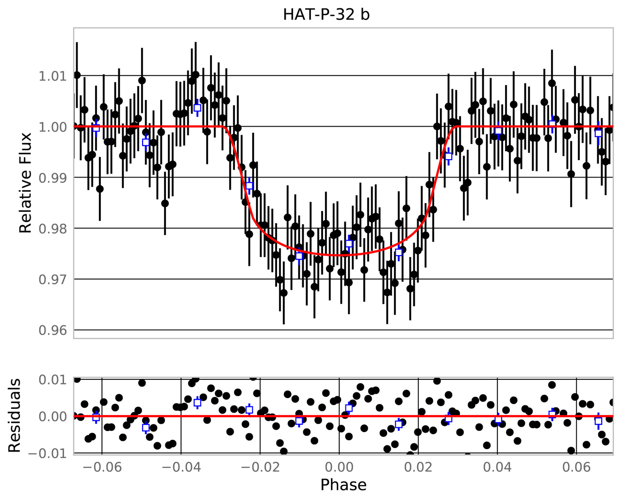
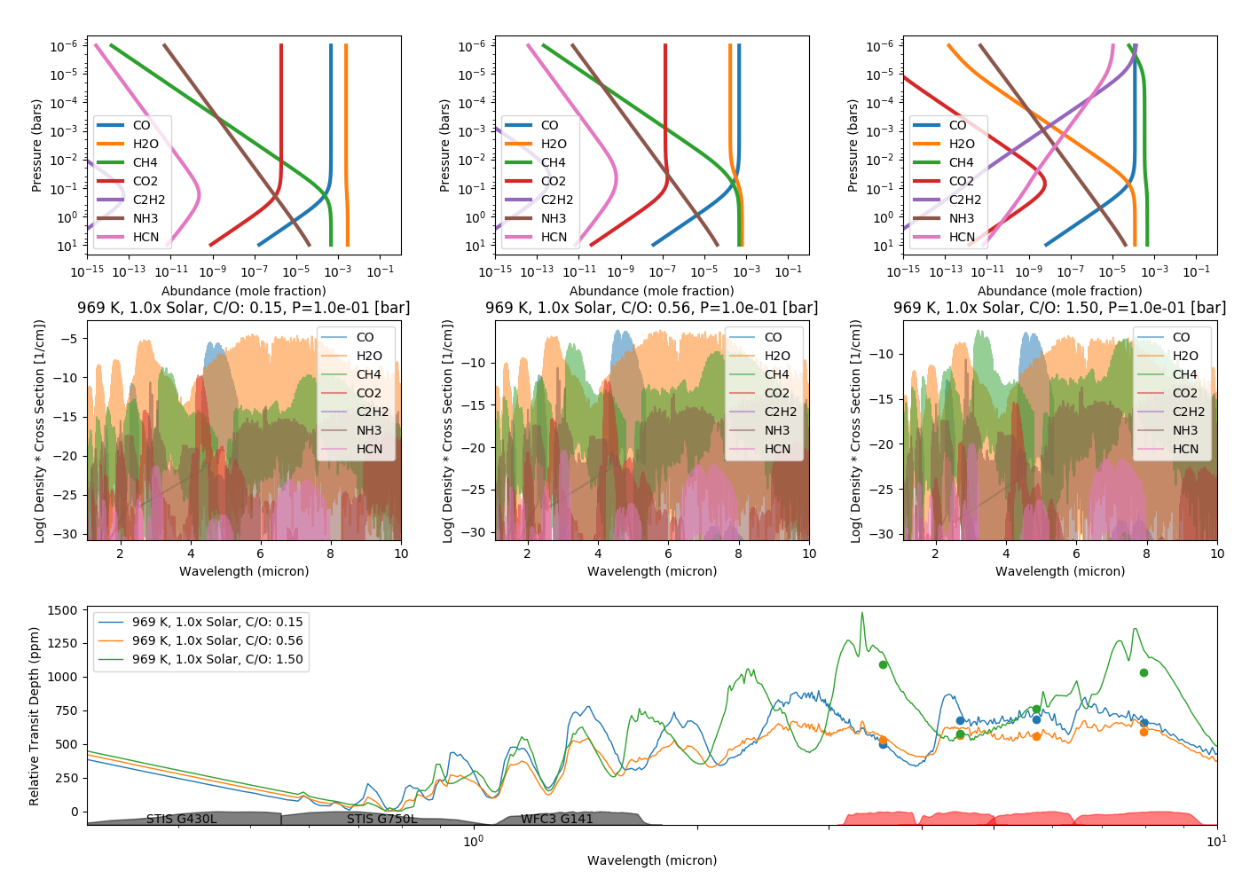
Exoplanet Calibration Bayesian Unified Retrieval Pipeline (EXCALIBUR)Kyle PearsonThe Spitzer Space Telescope has been observing photometric transits, eclipses and full orbit phase curves of 100+ exoplanets over the last 17 years in order to place constraints on their molecular mixing ratios and day-to-night heat redistribution. The manual interpretation of large datasets is labor intensive and subject to human error, the results of which are difficult to quantify. EXCALIBUR is a data analysis pipeline for transiting exoplanet science which leverages multiple instruments and a single orbital solution in a fully automated environment designed to keep the human out of the loop. The pipeline currently supports visible and near-infrared spectroscopy of exoplanet atmospheres using the WFC3 and STIS instrument on Hubble. Support for the infrared array camera (IRAC) on Spitzer is currently under development and will extend measurements out to 3.6 and 4.5 micron, useful for probing molecular features due to CO, CH4 and H2O and will provide constraints for planning future observations with infrared missions like JWST and ARIEL. |
|
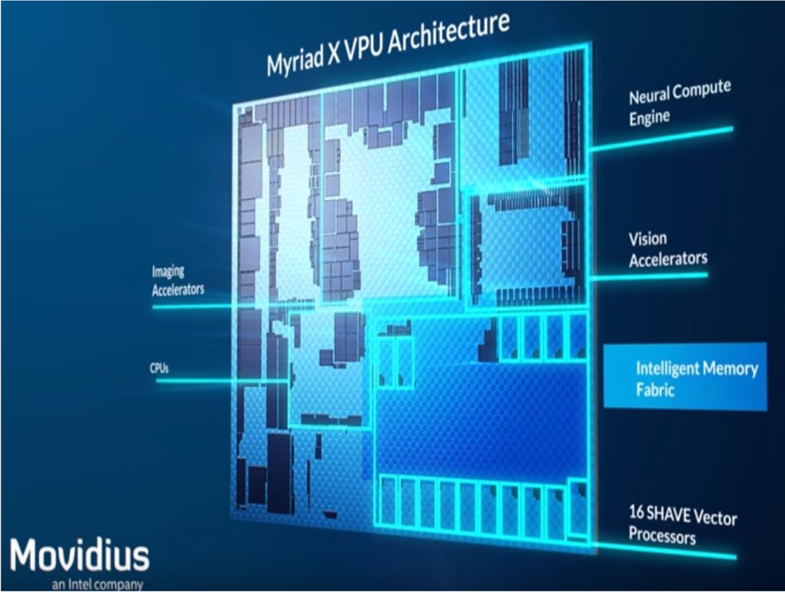
Onboard Intelligence with Edge ProcessorsEmily DunkelWe benchmark remote sensing algorithms and deep learning models on low power processors, such as Qualcomm’s Snapdragon and Intel’s Myriad X, onboard the International Space Station. Deployed models include neural networks trained on Earth imagery, as well as models trained on imagery from the Mars Curiosity Rover’s science and navigation cameras. This work is a step towards deployment of deep learning models onboard spacecraft or rovers, which could allow for autonomous data collection, targeted downloads, commanding space assets, and onboard science interpretation. |